You may have read books about how to navigate in a kayak. Chances are you were slightly overwhelmed by some of the techniques. They may give you the feeling that if you are not well versed in the finer points of parallel rules, magnetic declination and vector analysis you will end up drifting to the next continent instead of merely eating lunch on that pretty island you see less than a mile away. This article is not to tell you that you shouldn’t learn as much as possible about the technical navigation methods — such knowledge can indeed keep you out of deep trouble. However, there are times a more seat-of-the-pants style is called for. The ability to read the signs when you are out on the water is no less important than your most careful preparation before heading out. You need water awareness. Awareness of the conditions around you will help keep you safer even if you have carefully plotted your course before setting out.
If you are paddling due east from No Return Point toward Last Chance Island at a pace of 3 knots and there is a 1 knot current pushing down from the north what course must you steer so you don’t miss Last Chance Island? This is a fairly easy problem for plotting vectors of navigation and using that method you will choose a course of about 70 degrees. If you are paddling in thick fog with no wind, this is probably what you should do. But this requires that you know the speed of the current, that there be no wind to affect your course and that you know how fast you actually paddle. You also need time to plot out your intended course and make some vector diagrams. As a practical matter this usually needs to be done on shore.
In reality, you may change your destination on the water or, the wind may have picked up or, your current table does not provide information for the channel between No Return Point and Last Chance Island or you are getting too tired to maintain your usual pace. In other words, you may have no clue about the speed of the current or how fast you are paddling. You have no information on which to base a vector diagram even if your pencil hadn’t floated away. However, you can see the island. Part way across you can just make out a channel marker. By the way it is leaning over you know there is a powerful current flowing. You need to make it to the island and if you miss it you’ll be swept for miles before you fetch up on another safe landing spot. So how do you assure that you will get to your destination?
Ranges
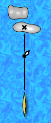
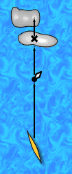
All the information you need is there before you. It is known as "natural ranges". A range is just a series of objects in a line. You and your destination describe a line and the channel marker is a third object on the same line. The buoy lies on your course to Last Chance Island and as long as the buoy stays lined up with your destination, you are on the line from your departure point to your destination. Look out towards the buoy and the island beyond. Choose a landmark on the island that is directly behind the buoy. The landmark can be a house, tree, rock or just a low spot on the island. The buoy is one end of the range and the landmark is the other. Now start paddling to the buoy. As you get out into the current you will start being swept away.
 |
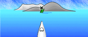 |
| If you choose the low spot on the island as your destination, the natural tendency is point your boat at it and keep it pointed the whole way. If there is a current or wind pushing left to right, you will be swept to the right. As you cross, your course will describe a long curve . At best you will have to paddle farther than necessary, at worst you might be swept beyond reach of your destination or into more severe conditions. You can detect the current by noticing the lean of the buoy and by the fact that the objects that used to lie on your course — the buoy, your destination, and the far hill — no longer line up as you proceed across the channel. As you get swept to the right, the far objects appear to move to the right, and the close objects seem to move to the left. |
You will notice that the buoy and your landmark start coming out of alignment. If the buoy is to the left of the landmark you need to turn left and keep on paddling. If the landmark keeps on moving away from the buoy steer more to the left and keep on paddling. Eventually the buoy will realign with the landmark. If the landmark drifts to the other side of the buoy adjust your course slightly to the right and keep on paddling. As long you keep the buoy and the landmark aligned, you are on a line straight across the channel.
This simple seat of the pants technique is all you need to take the quickest course across the channel. Paddlers in whitewater will "ferry" across a current by pointing up into the current enough that they don’t get swept downstream, while still moving towards the far side. This "ferry angle" assures they don’t get swept downstream into danger. You can do the same thing on the ocean. With a range you can easily find the proper ferry angle without knowing anything about the current or your speed. A range can be any two items that lie on the straight line of your course. They can be buoys or mountains, trees or anchored boats. If there are no stationary objects on the water, you may have to find a range nearer your destination. A rock on the beach aligned with a tree on the slope above may be all you can find. Two objects close together will not provide as sensitive a range as more separated landmarks. In narrow shipping channels such as rivers you may see artificial ranges — usually two towers set up at a bend in the river. The river pilots know that as long as they keep the towers aligned they are in the channel.
 |
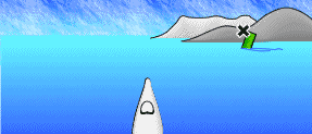 |
| When you notice the current, turn your bow slightly up into it. Adjust your course so that the landmarks on your range stay lined up as you get closer . If the closest object moves toward the left relative to the farther landmark, adjust your course more left. As the object starts falling to the right, adjust your course to the right. This will ensure the most efficient path across the current and keeps you out of any trouble that may be down-current. |
The principle of ranges is evident in everyday events. Driving down a road, the telephone poles zip by in rapid succession, while the mountains in the distance take much longer to pass by. The angle towards near objects changes faster than for distant ones. When you get in a current moving perpendicular to the course you are heading, you will see closer objects move faster than distant ones. By keeping track of the relative position of close and far objects you will be able to detect where the current is carrying you.
Drift
Detecting a current when you are in it can be very difficult even when you are drifting rapidly. When you are paddling in the middle of a current there may be no clue that it is there. Once your car gets going on the highway, with your eyes closed it can be hard to tell if you’re moving. It is when the car starts or stops that you wake up. You need to be aware of the clues. In a car it is the fence posts zipping by. In a current it may be the direction of the flow of kelp below you or the lean of a navigational buoy. You should also look for the wake made by the current flowing past stationary objects.
In a current waves will splash on the up-current face of a stationary object, and water directly behind the object will usually be smoother as the current eddies around. Depending on the angle of the light the rough water will either be lighter or darker than the smooth water. You will often be able to pick out a contrast in the color of the water which indicates the presence of a current. This change in color or tone is usually associated with a change in the speed or direction of the current. The different color is usually down-current from the obstruction causing the change.
If you don’t pay attention to the current and just try to keep your bow pointed at your destination, you will be swept in a long curve which at the very least will take you longer than a straight line course and at worst may sweep you out of reach of your destination. Even if you can’t read any sign of current in the water, it is worthwhile to pick a range as you start making a crossing. Double check the orientation as you go, you can quickly pick up any deviation from your course. You can also take a compass heading on your destination. If the heading changes as you proceed, you are being forced off course by a current or wind.
Currents are often more subtle than a wind, but a wind will drift you off course just as easily. A powerful wind can be pretty hard to ignore, but it is useful to be able to detect a high wind before committing to a crossing. An obvious clue is white caps. The presence of white caps and breaking waves is a good clue that there is a significant wind creating them. A change in the size of waves is also associated with a change in the color or tone of the water.
Obviously, most ranges will not work for the whole crossing. You will eventually reach the closer mark. It is then time to choose a new range. If the conditions are foggy, you might not be able to see your final destination. In this case you will want to try to find some closer landmarks. In the waters of New England this is often very easy. In some places there are lobster buoys every 20 feet. Even if you only have 100 feet of visibility they can provide several stationary landmarks to choose from. By choosing a pair that lie on your compass course you can try to keep them aligned. Take a look at your compass when you find a ferry angle that keeps your range aligned. If you run out of ranges along your course, this compass reading will probably work until you are able to find for a new one.
Be careful that you don’t choose a gull or seal’s head as one of your range points; even if they aren’t swimming, they are at least drifting with the current. You need something that is stationary. If you lose sight of any good ranges ahead, you can also use back ranges. Look back behind you and keep objects on your path behind you lined up. This is obviously not as convenient as a range ahead of you but can help you determine whether you are being swept off course.
If all you can pick out is your destination and your departure point, you want to keep yourself on a line between them. If your destination is directly ahead of you and you can see your departure point just over your left shoulder, you may want to adjust your course more to the left to get back on line. If your destination is off your right bow and your departure point is over you left shoulder, you’re probably doing all right.
Finally, you can use ranges to gauge your forward progress. As you paddle up a channel, look for a range off to your side. This side range can tell you how much progress you are making against a current. Forward progress is indicated by the near object falling behind the far landmark. You may find that for the last 10 minutes, while you have been happily paddling along, you were actually proceeding backwards. In which case you may want to ferry to one side of the channel and paddle where the current is slower.
Natural ranges are not a substitute for being prepared; they are a tool to use to keep aware of how you are doing. They are a quick system to double check what you may already know from other sources. Currents can be deceiving, the water can be glassy smooth while you are being swept dangerously out to sea, or drifting down into a tidal rip. Unlike taking a hike, when you stop paddling, you don’t necessarily stop moving. Where you are going is not always obvious from the immediately local conditions. You sometimes need to be able to look at more distant references to determine the true local conditions.
Learning to read the information presented by natural ranges is one step to gaining water awareness. It is worthwhile to pick out a natural range on your intended course no matter how benign the apparent conditions. This give you the chance to take action before the conditions are no longer benign. Natural ranges are an easy tool to use and they help you become more aware of the environment, by taking your eyes off the destination and making you look at the journey. With this increased attention, you will soon become aware of other clues to what the water around you is doing.